The Hennepin Canal Trail
The Hennepin Canal Trail is a pretty rugged trail that runs east and west next to the main Hennepin Canal, and north and south along the feeder canal from the Rock River to the main canal. The trail surface is a combination of crushed stone, dirt, gravel and paved sections.
The Hennepin Canal Trail (HCT) runs alongside the Hennepin Canal, from the Illinois River, at Bureau Junction near Hennepin to the Rock River where it meets the MIssissippi River at the Quad Cities. The HCT trail also includes a leg that runs along the feeder canal from the Rock River at Rock Falls south to the main canal west of Langley, Illinois.
At this time I have only ridden the northern part of the feeder canal from Rock Falls south for about 15 miles. From my research on the trail though, the traillink.com site says that the trail is a TOTAL of 104.5 miles with a post that says that the north/south feeder canal trail is 29 miles which seems accurate based on our ride. This would make the main east/west canal trail about 75 miles one way.
Our Ride on the Hennepin Feeder Canal Trail
We started our ride on the HCT in Rock Falls at the Rock River. We actually crossed the Rock River, on the bridge over the dam to start our journey south.
We rode south on the trail for about 15 miles (one way) to just south of Tampico, Il. and back. The trail was paved at first (the northern most part) although the paved part was not in very good condition and barely seemed paved at times.
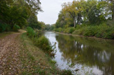
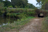
After the first few miles the trail surface became crushed stone that was loose at times with some gravel in places and then mostly a dirt trail in other parts.
The reason that I am describing the surface in so much detail is because this was a pretty difficult trail due to the surfaces. Of course, I ride a road bike with pretty narrow tires so this trail would be much better with a mountain bike.
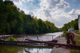
Aside from the trail surface, the trail was very flat and straight and ran along the west side of the canal the entire time. The scenery along this part of the trail was all pretty much the same. The canal on one side and a line of trees on both sides of the canal.
You could ride a lot of miles on this trail system but I think it really would be better with a mountain bike or at least a hybrid. You might also want to be sure to have water, a repair kit and spare tube since there are long stretches with no towns and where we saw very few people.
As I mentioned previously, at this time I have only ridden the northern part of the Hennepin Feeder Canal trail (south from Rock Falls). I still hope to ride the main east/west part of the trail and have updates for that part of the trail soon...
The Hennepin Canal Trail Maps
I am including the Google Maps version of the trail ~ so you can get right to it without having to search and zoom in ~ in addition to my GPS map on the Garmin Connect SIte.
Each map has different features that can be helpful so you can take your pick of which one you like the best.
Here is the GPS Map of Our Ride on the Hennepin Feeder Canal Trail through the GarminConnect site.
Here is the Google Maps version of the Hennepin Canal Trail.
| . |
Hennepin Canal Trail Photo Tour
Here's the photo tour of the Hennepin Canal Trail with plenty of first hand riding details. This ride was from late September, 2017.
Hennepin Canal Trail Home < you are here
Hennepin Canal Trail Photos 1 - Rock River and Northern Canal Ride
Hennepin Canal Trail Photos 2 - Northern Canal back to Rock Falls
Hennepin Canal Trail Video on YouTube
Here's the video of the Hennepin Canal Trail that I posted on YouTube.
Photos © Copyright Rob Chapman, about-bicycles.com. Photos with * Copyright Dale Kiffel.
- Bike Computers
- Bicycle GPS
- Bicycle Bags
- Bicycle Clothing
- Bicycle Lights
- Bicycle Locks
- Bike Parts
- Bikes
- Kids Bikes
- Exercise Bikes
- Bike Trainers
- Bicycle Car Racks
- Bicycle Hydration
- Bicycle Accessories
- Bike Blog
The HCT Photos1
The HCT Photos2
- Algonquin Road Trail
- Busse Woods Trail
- Chain O'Lakes Trail
- Chicago Lakefront Trail
- Deer Grove Bike Path
- Des Plaines River Trail
- Evanston Lakefront
- Fox River Trail
- Great River Trail, Illinois
- Great Western Trail
- Green Bay Bike Trail
- Hennepin Canal Trail
- I&M Canal Bike Trail
- Illinois Prairie Path
- Illinois State Beach Bike Path
- Inverness Trail
- Jane Addams Trail
- Kankakee River Trail
- Long Prairie Trail
- Millennium Trail
- Moraine Hills Trails
- North Branch Trail
- North Shore Bike Path
- Old Plank Road Trail
- Palatine Trail
- Paul Douglas Trail
- Poplar Creek Trail
- Prairie Trail
- Prospect Heights Trail
- Randall Road Trail
- River Bend Trail
- Robert McClory Bike Path
- Silver Glen Trail
- Skokie Valley Trail
- Thorn Creek Trail
- Virgil Gilman Trail
- Wauponsee Glacial Trail
- 400 State Trail
- Ahnapee Bike Trail
- Badger State Trail
- BATS Crystal Lake Trail
- Cannonball Path
- Elroy Sparta Trail
- Great-River-Trail
- Kenosha Trail
- LaCrosse-River-Trail
- Military Ridge Trail
- Oak Leaf Trail
- Peninsula State Park Trail
- Red Cedar Trail
- Root River and Racine Trails
- Seven Waters Trail
- White River Trail


